
Visualization for Planners Class
I created the graphics presented here as part of my class on visualization techniques for planners. We use different software such as Adobe Photoshop, Illustrator, Indesign, SketchUp, and ArcMap to create maps, renders, and diagrams that can be used to tell a story about a project.
Street Resdesign
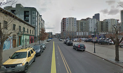
Lincoln St is a arterial street that connects downtown Denver with the south side of the city. Right now, this street is designed for cars only, has three lanes of traffic, two parking lanes, and a dedicated bus lane. The proposed design eliminates one lane of traffic to create a bike lane and expands sidewalks, creating a safer and more engaging experience for pedestrians and cyclists.

Context map
Capitol Hill is located directly east of Civic Center Park and the Colorado State Capitol. The neighborhood has a good walkability score that allows its residents to walk to the many breweries and bars found within the neighborhoods as well as to grocery stores and St. John's Cathedral. Even though the neighborhood is very close to the city center, getting there can be difficult due to the two arteries, Colfax and Broadway, that people have to cross if they want to walk there. Capitol Hill also has access to two parks within the neighborhood boundaries, Civic Center Park and Governors Park; however, these parks are not very attractive to people due to their size and design. However, the neighborhood is a 10-20 minute walk from Cheesman Park, a space that offers more amenities and is more attractive to people.

Streetscape diagram

Lincoln St is an arterial street that connects downtown Denver with the south side of the city. These streets are designed for cars only, have three traffic lanes, two parking lanes, and one bus-only lane. The proposed design eliminates a traffic lane to create a bike lane and expand sidewalks; this makes a safer and more engaging experience for pedestrians and bicyclists.
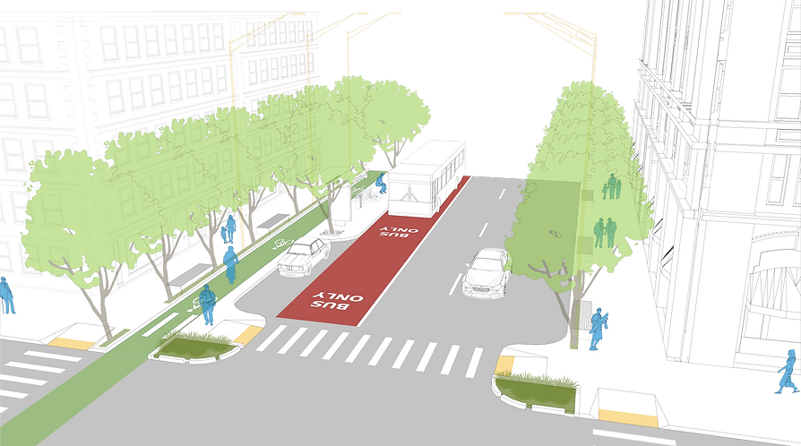
Street & Intersection Redesign
A Sunday afternoon in October. People are walking through this street to get to different places or simply, to enjoy one of the last warm days of the fall in their neighborhood. With the new street redesign, people can bike safely, enjoying the ride without worries because of its new protected bike lane. The new bus dedicated lane allows people to get to their neighborhood faster, and after they get to the station, they can walk home more comfortable and safe because of the nice sidewalks and crosswalks with new signages and art activation. Finally, the trees that provide shade and create a nicer walking environment.

A Sunday afternoon, in October. People are walking through this street to get to different places or simply, to enjoy one of the last warm days of the fall in their neighborhood. With the new street redesign, people can bike safely, enjoying the ride without worries because of its new protected bike lane. The new bus dedicated lane allows people to get to their neighborhood faster, and after they get to the station, they can walk home more comfortable and safe because of the nice sidewalks and crosswalks with new signages and art activation. Finally, the trees that provide shade and create a nicer walking environment.
